-
Title
-
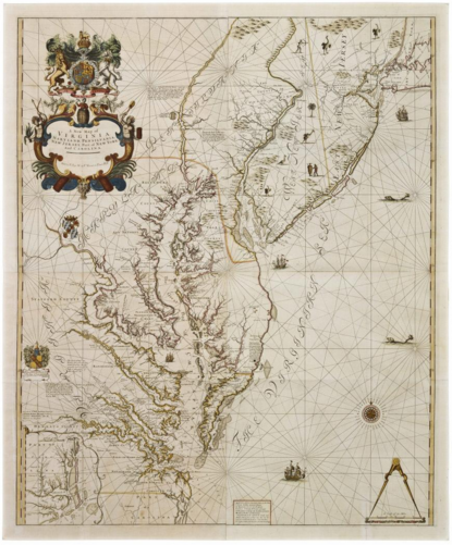
A New Map of/ VIRGINIA./ MARYLAND, PENSILVANIA,/ NEW JERSEY, Part of NEW YORK,/ And CAROLINA
-
Description
-
The upper left cartouche reads: "A New Map of/ VIRGINIA./ MARYLAND, PENSILVANIA,/ NEW JERSEY, Part of NEW YORK,/ And CAROLINA./ Sold by T. Page W. & F. Mount on Tower Hill"
The lower left cartouche beneath the coat of arms reads: "To M.r Micajah Perry of London Merchant/ This Map of VIRGINIA &c./ is humbly Dedicated and Presented/ Thornton,"
-
Label:
Map of the eastern portions of Virginia, Maryland, Pennsylvania, and New Jersey. The coat of arms of William III is above the cartouche in the upper left corner. The title is followed by the imprint "Sold by T: Page W: & F Mount on Tower Hill. Below the cartouche is the shield of Cecil Calvert, Lord Baltimore. In the center left are the coat of arms of the Perry family and the dedication To Mr. Micajah Perry of London Merchant/ This Map of VIRGINIA &c.a / is humbly Dedicated and Presented/ [erasure] Thornton,/ [erasure]." A scale of distances surmounted by a protractor is in the lower right corner.
In compiling A New Map of Virginia, John Thornton relied heavily on an earlier chart by Augustine Herrman, who immigrated to New Amsterdam as an agent for the Dutch West India Company prior to 1633. By 1660, Herrman had settled in the Chesapeake. The following year, Lord Baltimore granted him the first of several land grants that ultimately totaled between twenty and twenty-five thousand acres. In return, Herrman agreed to prepare a map of Maryland. He spent over ten years surveying the Chesapeake and its tributaries, finally sending the completed draft to London where it was engraved in 1673. Thornton would have been familiar with the work since it was considered the most accurate representation of the Middle Atlantic region at that time.1
Thornton made few changes to Herrman's rendering of Virginia and Maryland beyond correcting the geographical orientation from north to right, as drawn by Herrman, and depicting north at the top. Thornton extended the geography to include the northern parts of Maryland, New Jersey, part of New York, and Pennsylvania, located the site of Philadelphia, laid out in 1682 and thus too late to appear on Herrman's map, and included an inset view of part of Carolina in the lower left corner.2 He kept most of the names of settlements and plantations, although he changed The North Sea to The Virginian Sea. Thornton copied blocks of explanatory text from the earlier map, putting them in the same places, and kept Herrman's observations on the flow of the rivers. He reproduced notations such as the one that located where Sr Will Barkley, Conquered and tooke Prisoner the great Indian Emperour Abatschakin, after the Massacre in Virginia. However, Thornton improved Herrman's soundings in the Delaware and Chesapeake Bays, relying on a map that he published jointly with William Fisher for The English Pilot The Fourth Book.3
There are also artistic similarities between Herrman's and Thornton's maps. Both contain the coats of arms of King William III and Cecil Calvert, the second proprietor of Maryland. Some of the decorative ships included on Herrman's map appear on Thornton's. Even the protractor surmounting the scale of distances is similar on both.
One curious feature of the Thornton map is the coat of arms of the Perry family with a dedication to Micajah Perry, senior partner in the firm of Perry and Lane, one of the largest tobacco and fur-trading companies in London during the late seventeenth and eighteenth centuries. (fig. 83) They had mercantile interests in North Carolina, the West Indies, and Madeira, although their primary trade was with the tobacco colonies of Maryland and Virginia.4 Among the many planters recorded as doing business with the Perry and Lane firm were the William Byrds of Westover plantation and William Byrd II's brother-in-law, John Custis. Perry and Lane also acted as agents for the College of William and Mary and for Governor Francis Nicholson.
A close examination of the Perry dedication revealed an erasure, suggesting that this version of the map was not the first state published. The only known copy of the first issue is in the collections of the British Public Record Office. Although badly worn, that copy supplied the original imprint of Reeve Williams, John Thornton, and Robert Morden erased from both the cartouche and the Perry coat of arms on state two.
Upon John Thornton's death, the business passed to his son, Samuel, who inherited "all his Mapps, charts, copys, instruments, copper engraved plates and all other things belonging to my calling."5 According to Alice Hudson, chief of the map division of the New York Public Library, Samuel is known to have erased his father's name from copperplates, often inserting his instead.
It is likely that the first state of the map was published no earlier than 1701. It could not predate that year because the Perry family, whose arms appear on the first issue, received their armorial bearings in 1701.6 The map also bears the arms of William III. When Queen Anne ascended the throne in 1702, she significantly altered the royal arms. The date assigned to the second state, between 1723 and 1728, was based on the publisher's imprint. When Samuel Thornton died in 1715, William Mount and Thomas Page acquired the Thornton plates.7 Between 1723 and 1728, Mount and Page were also in partnership with Fisher Mount, all of whose names appear on the second state of A New Map of Virginia. Maryland, Pennsylvania, New Jersey, Part of New York, and Carolina.
1. The copy of Herrman's map in the John Carter Brown Library contains a paste-on slip that reads, "Sold by John Seller. Hydrographer to the King at his Shop in Exchange ally in Cornhill. London." Seller and Thornton frequently worked as partners from about 1677 to 1679. In association with Seller, Thornton published Atlas Maritimus and The English Pilot between 1677 and 1679. Simultaneously, Thornton became involved with The English Pilot, originally begun by Seller about 1671. Following Seller's death in 1701, Thornton formed a partnership with Richard Mount and continued the publication of The English Pilot. For other maps by Thornton derived from Herrman, see Custis Atlas Cats. 70 and 73.
2. The inset view of Carolina was copied from Thornton's A New Map of Carolina. See Custis Atlas Cat. 72.
3. Coolie Verner, A Carto-Bibliographical Study of The English Pilot The Fourth Book with Special Reference to the Charts of Virginia (Charlottesville, Va., 1960), pp. 10-11. Verner's observation that the soundings on the Colonial Williamsburg map by Thornton were borrowed from the Thornton and Fisher chart is in his unpublished notes, some of which are in the British Library.
4. During the early years of the eighteenth century, Micajah Perry's brother, Peter, served as a merchant in York Co., Va., and his nephew, Micajah Lowe, acted in the same capacity in Charles City Co., Va. For a complete discussion of the Perry firm and their activities in America, see Price, Perry of London.
5. Tyacke, London Map-Sellers, p. 145.
6. Price, Perry of London, p. 22.
7. Alice Hudson, "The Grand Samuel Thornton Sea-Atlas: a monument to the Thames School of chartmakers," Map Collector, LXV (1993), p. 3.
-
Identifier
-
Acc. No. 1940-418
-
Creator
-
John Thornton
-
Alternative Title
-
Map
-
Date
-
1723-1728, originally published ca. 1701
-
Medium
-
Black and white line engraving with period hand color on laid paper
-
Format
-
42 1/8 x OW: 34 5/8"
-
Contributor
-
Museum Purchase
-
Publisher
-
Thomas Page and William and Fisher Mount (1723-1728)
-
Colonial Williamsburg Foundation
-
Date Available
-
image
-
Rights
-
Images of some of the material in our collections may be licensed for publication. Please fill out an application for permission to publish or permission to exhibit.
The use of museum objects is subject to curatorial review and approval. Occasionally, new photography is temporarily restricted for first-time use by Colonial Williamsburg. In addition, any photography of visitors or personnel that has not been model-released is restricted to in-house use.
-
http://research.history.org/library/visit/visual-resources/licensing/index.cfm
-
Spatial Coverage
-
Originated in England, London