Site Areas Map
Item
-
Description (Dublin Core)
-
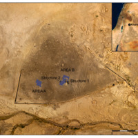
Aerial photograph of the Epipalaeolithic
site of Kharaneh IV. This overview of the site
documents the extent of the site shown as the darkened chipped stone pavement on its surface. The Wadi Kharaneh is visible in the foreground, to the south of the site, and contemporary military berms are visible to the east and north. The location of Kharaneh IV within the southern Levant is shown inset. The extent of excavations areas A and B are shown by the highlighted areas, and arrows point to the locations of Structures 1 and 2.
-
Creator (Dublin Core)
-
Fragmented Heritage Project
-
Identifier (Dublin Core)
-
KHIV.OS.4

 KHIV Site Areas Map