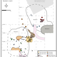
Site features Map
Item
-
Title
-
Site features Map
-
Description
-
Plan view (top) of Structures 1 and 2, and
section view (bottom) of Structure 1. Top:
Simplified plan views of Structures 1 and 2,
showing their proximity to each other, as well as several caches of flint, a cache of burnt horn cores, and a large hearth in between the two structures. Caches of marine shell, and bone and flint are also noted within each structure. Bottom: Section of Structure 1 showing the covering orange sand, burnt superstructure and three superimposed, compact floors, and photographs of articulated aurochs vertebrae found on the uppermost floor (left), marine shell and red ochre cache from the burnt layer (center), and burnt flint nodules in the burnt layer visible as the orange capping sand layer is removed (right).
-
Creator
-
EFAP Archive
-
Identifier
-
KHIV.OS.5
 KHIV Site Features Map